Always on the lookout for interesting places to travel, I am in Jordan, a small country wedged between Israel, Saudi Arabia, Iraq, and Syria. Its land mass is just under 35,000 square miles, landlocked but for 16 miles along the Gulf of Aqaba. There is evidence of human activity dating back many thousands of years; human figures from 7500 BC.
Originally settled by Bedouins, Jordan came under Greek, Roman, and Turkish influence. It became a British mandate in 1916, and ultimately won independence in 1946. The population is currently 10 million of whom 92% are Muslim and 8% Christian. Jordan has been a refuge for many people from Palestine, Egypt, and Syria, fleeing violence and persecution. It is a stable democracy, one of the few in the Middle East. Literacy is high at above 90%. Healthcare is available to all. As in California, water is scarce.
Our group of eight and a guide begin our journey in the capital, Amman, a lovely city of 4 million people, constructed on 23 hills. We walk everywhere through a variety of neighborhoods and visit a mosque, Roman ruins, museums, a farmer’s market, and eat some tasty local food.
We travel north to Jerash and roam about through the extensive ruins of this first century Roman city. Olive trees dot the hillsides above the Jordan Valley where much of the country’s fruit and vegetables is grown.
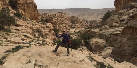
Next, we head south for six days of hiking including three nights of camping. Camping, really? I’d sworn off sleeping on the ground long ago. On the first night after 12 miles of hiking with an elevation gain of 4800 feet, my body is dead tired. I am sticky with sweat from the arduous activity but skip the cold water bucket shower for obvious reasons. The campsite sits on a ledge overlooking some glorious scenery.
I lie in my tent on a mat with warm furry blankets. The moon is full. Dogs are barking and donkeys braying somewhere far away. Overnight the donkey that accompanies us to carry extra water, runs away. He clearly wasn’t happy climbing some of the more difficult parts of the mountain. The next day we have a new donkey that is far more cooperative.
After the next hike, I break down and take the cold water bucket shower. I discover why I skipped the first one. The others who are within earshot count the number of times I yell as the cold water hits my body. The second campsite, in a setting even more beautiful than the first, is in a valley surrounded by rock formations that resemble Hobbit dwellings.
The following day’s hike ends in Little Petra, a Nabataean settlement dating to the year 300 BC whose specific purpose is unknown as there is no historical record. It is posited that it served as a spa to Petra, a much larger (and infinitely more famous) city located a few miles away. We are followed to our third campsite by a cheerful fluffy white dog, and visited at dinner by a hungry feral cat.
The third night of camping is something else, quite a change from our relatively peaceful previous nights. The wind chaotically whips our tents making sleep sporadic at best. But that is mild compared to what we experience in Petra the following day. More on that in a minute.
Petra was originally settled by Arabian Bedouins, and in the first century BC, became an important overland trading hub located at the convergence of several trade routes. The Nabataean development of sophisticated water systems enabled them to control the region and establish a flourishing kingdom. As the practice of agriculture increased, Petra became economically powerful. Magnificent buildings and tombs were carved into the mountain faces. Women had high status, could inherit and bequeath land, and own businesses. The Nabataean dominance ended at the beginning of the second century AD when the economy declined due to the loss of overland trade routes and Roman occupation. An earthquake in AD 363 destroyed much of Petra, which was then abandoned several centuries later. It was rediscovered in 1826, with the first archeological excavations occurring a century later. It was designated a UNESCO World Heritage site in 1985.
Now about what happened to us in Petra. Knowing about the forecast of high winds and drenching rain, we leave camp early, arriving at the city gate at 7:15 am. In five hours and at a quick pace, we are able to see most of the significant sites spread out over the expansive mountainous landscape including the Treasury, the Monastery, “downtown”, and the many tombs.
The wind is so fierce that my eyes and ears fill with stinging sand. Items at souvenir stands fly through the air and crash to the ground. Debris is everywhere. Then the authorities do something rare. They order Petra closed and evacuate the entire population of visitors because the high, narrow canyons in the city are prone to flash flooding. Unable to navigate the disorganized crowds waiting for buses to take us out, our group fast walks three kilometers up the steep hills to the city gate, all the while dodging fleeing camels, donkeys and vehicles. Quite an exciting experience!
My stay in Jordan concludes with a jeep ride in the back of a pickup truck through the photogenic red desert of Wadi Rum, and memories of a unique and historic country.
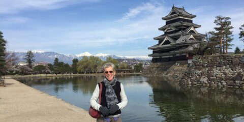
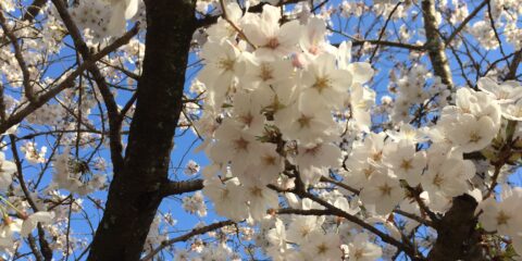
We spend three days in Kyoto, an exciting city teeming with life and energy, streets crowded with residents and visitors hurrying in every direction. We visit famous temples, palaces, and gardens. Loveliest, though, is the Philosopher’s Walk, a two km path running alongside a canal lined with cherry trees in full bloom and so named for a famous Japanese philosopher who reputedly did his most creative thinking while taking his morning constitutional here.
Most memorable, however, is a tea ceremony demonstration at the tea house of a Swiss expat master tea maker named Michael.
Last fall, I planned a solo three week trip to Japan, a rather ambitious, complicated, itinerary covering quite a bit of geography. Although I’ve traveled alone many times, it has generally been on an organized trip or to see friends. So I had some trepidation about executing all the details by myself. Thus I was delighted when my friends, Debbie and Mike, enthusiastically agreed to join me. As it turns out, this was well-advised. I need supervision. Over the course of just the first few days, I leave my purse on a bench (luckily Mike notices), I obliviously walk away from my suitcase in a train station (Debbie calls my attention to this omission), I nearly knock a conductor off the platform barreling along in a hurry not to miss a train, I mistake a passenger who wants the seat next to me for the conductor collecting tickets, I misplace train tickets and keys to hotel rooms, and lose my gloves! We sure laugh a lot.
I am in Sydney for five days. The weather is perfect (apologies to those of you who are suffering the vicissitudes of winter). The city is urban, attractive and surrounded by water. Ferries and pleasure craft are everywhere. There is no doubt that for me, the standout is the Sydney Opera House, gorgeous and innovative architecturally, situated on a promontory at the edge of Sydney Harbor that was originally a meeting place for indigenous people. While I have seen photos of this iconic building over the years, viewing it in person at different times of the day in changing light, is mesmerizing.
Designed by Danish architect Jorn Utzon in the 1950s after an international competition, the plans were considered by some too forward-thinking and were initially discarded, only to be retrieved later due to promises of a three year construction schedule at a relatively modest $7 million. Alas, as with so many projects, there was insufficient consideration given to engineering issues which caused the design to change continually. The bottom line is that it took ten thousand workers fifteen years at a cost of $107 million to complete the ten sails made up of one million self-cleaning ceramic tiles. Finally opening in 1973, the structure has six different theaters, is now a UNESCO World Heritage site and is almost universally acclaimed as one of the most stunning and creative buildings anywhere.
Adjacent to and nearly surrounding the Opera House is the Royal Botanical Gardens, an Eden between the tall city buildings and the Harbor. Having a tropical climate, Sydney’s foliage grows bounteously and the trees, in particular, are commanding and capacious.
For the last portion of my Australian journey, I fly to Melbourne from where I am driven three hours to The Great Otway National Park in the state of Victoria. There I meet up with four other hikers (three Aussies and a Brit) and two guides, for a four day hike called The Twelve Apostles Walk.
Before we begin the Walk, we’re given gators. I think we must be in for wet weather, but no, the gators are to protect ankles from snake bites as all snakes in the area are venomous! We’re told to watch out for jumping ants as they have a nasty sting and for a variety of spiders that are also poisonous. I begin to have second thoughts about this hike.
The trail hugs the ocean coast for a distance of one hundred km. We walk just under fifty of them, the path undulating through bushes and trees shaped by salt air and wind.
I keep my eyes on the roiling, foamy sea below, endlessly stretching wide and wild, finally dropping down beside it to tramp across the soft, white sand.
We see kangaroos and wallabies by the road, on the path, on the beach.
Clouds, dark and darker, fill the sky, the sun casting its rays randomly on the water; the crack of the breaking waves in the distance a constant companion.
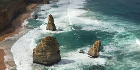
And on the final day of the Walk, we reach the Twelve Apostles, although there aren’t twelve and never have been! Originally, there were nine that were called Sow and Pigs by the local farmers. Not being all that catchy, it was changed in the mid-twentieth century to its current name, apparently a good marketing move as it then became a popular tourist destination. There are now seven limestone stacks (two collapsed due to erosion) and they are quite a sight from the trail, the beach, and most spectacularly, from a helicopter.
I happily conclude my first time in Australia having visited with old friends, gained some new ones, and walked some dramatic landscapes.
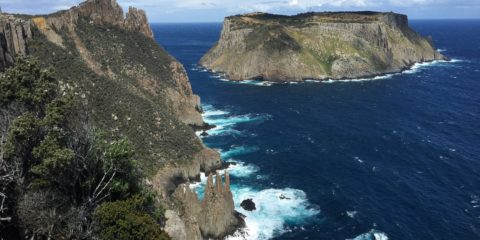
I am in Tasmania (Tassie, as it is called locally), the largest Australian island south of the Australian mainland. It is mainly wild and uninhabited, especially in the west. Hobart, in the far southeast, is the capital, and is a lovely, cultured city.
In 1803, Britain invaded Tasmania and outsourced their convicts to eleven penal colonies in Australia, among which was Port Arthur, established as a prison in 1833.
The treatment of prisoners was brutal. The offenses that brought them to Port Arthur were often ridiculously minor, horse theft as an example. The philosophy of correction was to “grind rogues into honest men” by requiring them to work twelve-hour days, six days a week, doing back-breaking labor while manacled one to another by heavy chains. At night, after work, they were required to attend classes and spend Sundays in church. Their living quarters were tiny cells, damp and inhumane quarters in inhospitable climate. It is no wonder that many men were broken. Now a UNESCO World Heritage site, it makes for sober viewing.
There are a number of adorable animals here in Tasmania: the wombat, a small bear-like creature that looks very cuddly; the Tasmanian Devil, sadly being eradicated by a cancer-like tumor that is spread when the Devils bite each other in the face; the platypus, an incredibly cute member of the monotreme family that has a duck-like bill, big webbed feet and a soft, roundish body; and the Bennetts wallaby, a kind-of junior-size kangaroo. Regretfully, I haven’t seen any of these critters in the bush, only taxidermied in the Hobart Museum. Hoping to see them on The Three Capes Walk, I have no luck.
Speaking of that Walk (what Australians call a hike), I join a group of twelve (eight Australians, three other Americans) and three guides for a four day hut-to-hut traverse across the Tasman Peninsula.
We hike 16-21 km a day through varied terrain, including dolerite cliffs
and a eucalypt forest.
Unlike in California where a single species of eucalyptus tree was introduced and is nothing more than a messy nuisance and a fire hazard, there are one hundred and thirty varieties here, many of which have colorful bark and flowers.
The Three Capes are called Raoul, Pillar, and Hauy and each offers stunning views across the great Southern Ocean where the next land mass south is Antarctica.
The first two days of the Walk are sunny and warm. The third day is full-on Tassie weather. We set out all bundled up in driving rain and gale-force winds, pushing forward, huddled over protectively. Then at about noon, the sky clears and the sun comes out but the wind doesn’t diminish. It blows steadily with gusts of up to 70 or 80 km per hour. This is serious wind!
On our final morning, we are required to wake up at 6:00 am and be on the trail by 7:00 as this is the longest hiking day yet: 21 km. The wind is less severe but it is awfully cold. I put on every stitch of clothing I brought with me. It is not enough.
Once again we see beautiful ocean landscapes juxtaposed with dolerite columns soaring from the sea.
The highlight, though, is a silent walk through the rainforest on Mount Fortescue, the highest point on the Tasman Peninsula. I am alone among the canopy of trees,
five-trunked Myrtles, giant ferns, rocks and fallen tree trunks smothered in thick green moss.
The forest floor is carpeted with leaves and bark. The hush is disturbed only by birdsong and the rustling wind. I am aware of all my senses, completely present in this intimate environment. Such a magnificent way to finish an unforgettable adventure!
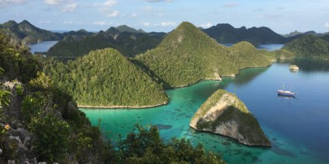
I’m sitting on the top deck of the twenty-seven meter Indonesian-constructed schooner called Shakti, my home for twelve days.
The boat gently plies the Indo-Pacific water of the Muluku Sea in which Raja Ampat, a province of Papua, sits. Raja Ampat, meaning Four Kings, is located in the far northeast of Indonesia, and is comprised of over six hundred islands out of the seventeen hundred island chain that makes up Indonesia, the fourth most populous country in the world with 230 million inhabitants. It covers one seventh of the equator’s length!
There are nine of us plus seven crew, three guides and a dog. We are here to snorkel one of the most remote and spectacular coral reefs on earth and see some of the three thousand species of fish that live here. It does not disappoint. We snorkel twice a day, each time for approximately two hours, each time in a different place, characterized by different coral. Raja Ampat has optimal conditions for the growth of coral: year-round sea temperature from seventy to eighty-five degrees and plenty of sunshine for photosynthesis. There are hard and soft corals in various colors. Some look like tubes or horns,
others like branches of trees, brains, elegant fans,
tables
or exquisite pottery.
It is as though a most creative landscape architect designed acre upon acre of the lushest and loveliest underwater botanical gardens. I am mesmerized.
There are so many different kinds of fish that it takes the lead guide several evenings of slide shows to get through all the descriptions! There are butterfly, angel, and trigger fish, damsels, fusiliers, groupers, puffers, and my personal favorite, sweet lips, among many more.
Their adornment and color dazzle the eyes. Pink, red, orange, blue, green.
Some are outlined in the most gorgeous shades of aquamarine or neon yellow.
Stripes, dots, zig-zags. Pointed snouts, sloped heads, disc shaped. Algae eaters, coral cleaners, predators. Where some reefs might have seven varieties of a particular species, Raja Ampat has fifty!
My cabin is located under the galley and my daily alarm clock is the clanging of pots and pans above at 5:00 am. I’m grateful to be awakened early so that I can enjoy the quiet before sunrise up on the deck. The only sounds are the bird calls across the inlets where Shakti is moored at night.
Although the air and water temperatures are in the eighties, I get cold easily. So to snorkel, I wear a full-length body skin and on top of that, my shortie wetsuit. It’s near impossible for me to get into the latter by myself due to it being very tight so I have one of the crew give me an assist by hoisting it up while I jump in the air, a ridiculous sight!
While snorkeling, I see a huge black manta ray gliding gracefully below me, a large frilly woebbegong shark rousted out of its sandy hiding place by a curious guide, a long black-tipped reef shark cruising away,
a hawkbill turtle startled by onlookers and fleeing to safety.
And the giant clams! Multicolored, mammoth, some five feet across, maybe hundreds of years old.
In the lagoons where we snorkel, the sea floor is a multitude of depths and is densely foliated with a plethora of textures and shapes in the most stunning shades of magenta, mauve, purple, aubergine, turquoise, royal blue, light blue, lemon, peach, and sea green. This palette of color makes me think of Monet’s water lilies paintings.
Floating just a few inches above the various corals allows me to be as close as possible to the fish swimming in and around the branches and anemones.
I hike to the top of a few of the many mushroom-shaped limestone karsts that rise up vertically in the lagoons and am treated to magazine-cover views of the surrounding areas.
I paddle board and kayak on the placid aquamarine water. I love seeing the landscape from every available vantage point.
And yet the best is saved for last. The final two snorkel outings are, simply put, awesome. Here in the vast deep blue sea swim millions of fish, no exaggeration. It is difficult to take it all in. School after school pass by: barracuda;
snapper;
bream; surgeon; unicorn;
squirrel; halfbeak; sargent; wrasse; giant bumphead parrot fish. One guide counted seventy-three of the latter.
The only comparison that comes to mind is the great migration on land from the Serengeti in northern Tanzania to Masai Mara in southern Kenya. The fish surround me, every color, shape and size. Such an unforgettable and sensational finish.
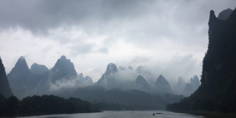
Guilin and Yangshuo are cities in Guangxi Province in the southwest of China. They are known for their fascinating landscapes, most notably the weathered limestone formations called karsts. Stone mountains covered in lush green vegetation, they randomly dot the land, suddenly rising and falling steeply for miles around.
The Li River cruise is a four hour excursion beginning in Guilin and ending in Yangshuo, the purpose of which is to marvel at these natural creations that line the river. On the day I took this cruise it was raining. The wind was blowing hard enough to continually turn my umbrella inside out while I stood on the top deck being mesmerized by the fantastical shapes.
While the experience would have been entirely different had the sun been shining brightly and the sky a clear blue, what I loved so much was the mist billowing between and around the karsts, giving the scenery a moody, mysterious feeling.
I couldn’t look away, the girth and height and proximity of one to another constantly changing.
There are two departure terminals, one for Chinese-speakers; the other for foreigners. One hundred boats each carrying one hundred passengers make this trip each morning, whatever the weather. The river is full of other boats too, water taxis and smaller sight-seeing vessels.
Waterfalls come rushing down the mountainsides.
All of it is magical, different from any scenery I have previously seen.
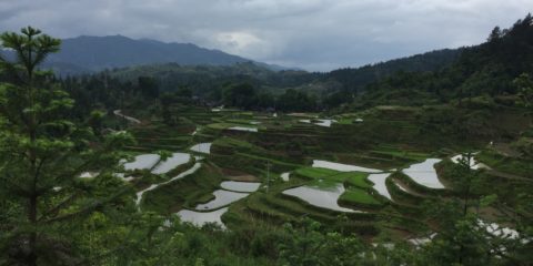
There are 8 of us and a guide who travel through the primarily rural province of Guizhou in southwest China for seven days. The majority of the people living here are Miao (pronounced “meow”), also known as Hmong. As a minority, their ancestors came to this region from far in the north of China more than 3,000 years ago to escape oppression by the Han majority. There are many different Miao villages, each with distinct dialects, clothing, food, and customs. We visit a number of them, some located in remote mountain areas accessible only by long, winding, roads. Many inhabitants are farmers and rice is their main crop. The landscape is steep, lusciously green, and terraced with rice fields, stunning to behold.
We walk through villages called Long Skirt and Short Skirt (the Long Skirts look down on the Short Skirts because years ago, the latter took land from the former. Intermarriage between the two is frowned upon). Miao villagers are friendly and often invite us into their homes for a meal. The dark brown houses built of stone, brick and wood, have roofs covered with deep charcoal-colored tiles that are locally made and lovely to look at, high up in the verdant mountains. We see rice barns standing on stilts in the water to keep the rats from getting into the rice.
We visit Dong villages whose residents came from southeast China at about the same time as the Miao arrived in Guizhou and for the same reason. One village, Zhanli Dong, is called the “birth control village” due to its long-standing rule prohibiting a couple from having more than two children. What makes this especially interesting is there is an herbalist who assists in determining the sex of each child. Several months before wishing to become pregnant, the woman drinks from one of two wells: acidic if a girl is desired; alkaline if a boy. The herbalist tells the woman what to eat during the same time frame depending upon the desired outcome. Her accuracy rate is said to be 98%. That is, 98% of couples have the desired one boy and one girl families!
We drive on high speed freeways built only recently, tunnels bored through the many karsts (weathered limestone formations) that stud the land. Our guide tells us how quickly China has changed, sky-high skyscrapers springing up at record speed transforming what was farmland 20 or 30 years ago into modern cities of 4 million or more today. Softening the edges, roses of every imaginable color line the roadway medians, a delight for the senses.
We learn about Mao, how he was both good and bad for China. As Chairman, he distributed land to the millions of impoverished farmers to enable them to have a better life, something for which they and their descendants are still grateful. At his direction, intellectuals and landlords, among others, were imprisoned or murdered during the Cultural Revolution, a terrible disaster for the country, by most accounts.
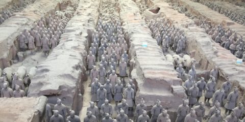
You know how sometimes you learn about a movie or a book and are so eager to see or read it that expectations are sky high? And then the reality doesn’t meet expectations because they had become so unrealistic? I had concern that seeing the Terra Cotta Warriors in Xi’an could be one of those experiences for me. But it wasn’t. It made me cry.
Here’s the back story. In 221 BC, a king named Qui Shi Huang became the first emperor of China. He was 39 years old. His dynasty was called Qui (pronounced Ching). There were then 20,000,000 people living in China (today, there are 1.3 billion). Qui was powerful and charismatic. He unified all of China with written language and currency. It was very important to him to protect his afterlife, so at the age of 13 when he became king, he began construction of what would become a 56 square kilometer burial site consisting of his tomb (what appears to be a mound of grass-covered earth originally 120 meters high), and 600 satellite tombs. The written history tells us that 720,000 forced laborers constructed this enormous undertaking that included 8,000 clay warriors of various ranks, as well as clay horses and 40,000 weapons.
One day in 1974, a few local farmers were digging a well and accidentally came upon a startling discovery. They found what would turn out to be the Terra Cotta Army! Excavation began immediately. What archeologists exhumed were fragments of clay soldiers and horses. It turns out after Qui died of mercury poisoning at the age of 50, a general ransacked the satellite tombs destroying the soldiers and taking the weapons. Apparently, he didn’t want Qui to have such a fabulous afterlife. And obviously, Qui’s unification of the country wasn’t as successful as Qui thought! The tomb itself, however, has never been opened as it was dug so deeply underground.
To date, 1,000 warriors and horses have been reconstructed.
Archeologists painstakingly put the fragments back together like jigsaw puzzles and placed the reassembled figures as they originally stood.
Each laborer was an artisan who created a soldier in his own likeness, only taller. Individual warriors took 3 months to make and are entirely unique with carefully detailed hairstyles, facial hair, fingernails and clothing.
The figures were then painted but the archeologists made a mistake back in 1974. As soon as the 5-meter-deep pits were opened and were exposed to air, the paint oxidized and faded immediately.
I felt awed and touched by this magnificent display of art, culture and history so beautifully and lovingly restored.
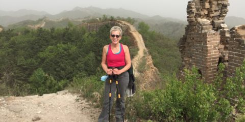
Almost everything in Beijing is on a large scale: the size of the city, the population, the public spaces. Tiananmen Square and the Forbidden City are two of the most prominent examples, both immense and fascinating. And even more so is the Great Wall, a part of which I had the pleasure of hiking this week.
The Great Wall was built continuously from the 14th through the 17th centuries during the Ming Dynasty in order to protect China from Mongol and later, Manchurian invaders. It runs a distance of 8,850 kilometers east to west. Of that, where the physical terrain was barrier enough, wall was not constructed. So the actual man-made portion is 6,230 km long. The builders were military men and paid laborers.
Construction materials included mud, brick and rock. In some areas, the new wall incorporated previously built walls from 1,000 years earlier. New material was simply added on top of what was already there. On one brick, our guide pointed out an insignia which showed (in Chinese, naturally), the year (1579) of construction and the name of the unit that built that particular tower.
There are 600 kilometers of the Wall located in the vicinity of Beijing. The section I visited is 130 km northeast of the city. Called Pan Long in Chinese, meaning Winding Dragon, it is aptly named as it curvaceously crosses the expansive mountainous terrain. And now in spring, trees and shrubs are newly leafed out and there is a profusion of wildflowers.
Our small group traverses approximately 9 km, passing through twenty or so guard towers in various states of disrepair. This section of wall has not been renovated and the footing is challenging due to the many missing bricks and stones. In fact, during the Cultural Revolution, the government encouraged farmers living in proximity to the Wall to remove bricks and stones to build farmhouses. Likely because of the condition, this section of the Wall is sparsely touristed. We see only a handful of other hikers during the afternoon.
The only unfortunate thing, if one can really complain about anything while on the Great Wall, is that an unexpected dust storm blew in overnight from the Gobi Desert north of us making the air thick, yellow, and murky. The result was restricted visibility and it was difficult to see the contrast between the wall and its surroundings. Even so, I could not go too far without stopping often to admire and to reflect upon the accomplishment of this remarkable endeavor.
It rains but not on our parade. That is, the other night it poured but not until we were returning from dinner. One morning at six, there was a downpour (even though the weather app on my iPad told me it was fair in Hoi An- so much for accuracy), but an hour and a half later, it was a glorious day.
It matters because this is a bicycling trip. There was one drizzly morning but otherwise it has been clear and so hot (ninety degrees and very humid), that when the group stops for a break, I look like a greased pig, sweat sliding off my body in sheets. The sweat mixed with sunscreen dripping into my eyes makes for very challenging navigating. We stopped by Red Beach (where the American troops landed in the War), China Beach (where they went for R&R), and one of the many areas thick with vegetation (where the Vietcong hid from them).
The terrain is mostly flat and our riding takes us through country
and seaside villages, alike.
Thankfully, the traffic is less daunting than it was in Hanoi although I feel a little intimidated when a noisy truck comes up behind me, passes too close, and then leaves a belch of black exhaust in its wake.
One thing there are a lot of are cemeteries. They are huge and seem to take up more real estate than any other enterprise. And they are beautiful.
The ordinary Vietnamese house is modest but the mausoleums are imposing with many columns and colorful tile work. There were over two million people who left the country on boats after 1975 to escape starvation and persecution. Many went to America, Australia and Canada. They were largely poor and uneducated but worked very hard at labor-intensive jobs and sent money back (hidden in umbrellas or wrapped in tobacco leaves, to avoid confiscation upon arrival) to their families who used it to build the burial chambers. This was a very important value to that generation, reverence for the dead. Now, however, according to our guides, the children of the boat people, educated and affluent, are motivated by prestige, and send back money in order to build the most impressive funeral edifices (perhaps the local version of keeping up with the Joneses!).
Our last stop, Saigon (the Vietnamese still call it Saigon even though the official name has been Ho Chi Minh City since 1976), is a world-class city.
Cosmopolitan, it is filled with skyscrapers, traffic, expensive shops and restaurants. In fact, it feels like New York to me, quite a surprise.
One day, we cycle in the Mekong Delta, the rice basket of Vietnam, through rice paddies
and dragon fruit plantations.
Another day, we ride to the Cu Chi Tunnels, the system of underground tunnels, 250 km in length, built over a twenty-year period (1948-68) by the Vietcong guerrilla fighters and used by them in the wars first against the French and then against the Americans. We had the good fortune of learning about this from Mr. Tam, a seventy year old former member of the Vietcong, who lived in the tunnels and lost an arm and an eye fighting the Americans. We then saw some of the tunnels themselves.
And amazingly, after having been on my bicycle for more than 161 miles, I find myself comfortably flowing with the traffic. There is a fluidity to the way the vehicles move with one another as though choreographed. There is something beautiful about it, like dancing, and I am thrilled to be a part of it.
Here are some facts you may not know: there are seven million people living in Hanoi. Of these, four million have motorbikes. I believe I saw most of them in one day. And the drivers operate them as though there was no other traffic, either vehicular or pedestrian. They do not yield to anyone. Good luck crossing the street. They park on every sidewalk. You have to walk in the street in order to avoid them, a hair-raising experience as, at any moment, you might get side-swiped by one of them. Our guide says that after a few months, you get used to this.
Ah, now, Halong Bay is another story entirely. A UNESCO World Heritage site, Halong Bay is located about three hours northeast of Hanoi. Three hundred sixty hectares in size, it has nineteen hundred and sixty-eight limestone islands or karsts of varying sizes and shapes rising straight up from the Bay, a very dramatic sight! Gently moving amongst and between them on a Vietnamese junk and by kayak is magical. Doing tai chi on the boat deck just after sunrise is an experience I won’t soon forget.
Back in Hanoi, I begin my day at six in the morning with a laughing yoga class on a downtown street. There must have been fifty or more laughing yogis, led by a charismatic teacher who had us doing the funniest movements with much laughter. It looked to me as though half were tourists and half local people. What a wonderful way to begin the day! And such a model for intercultural relationships. If everyone started their day with laughing yoga, there would be a lot less conflict in the world and a realization that we have more in common with each other than we have differences.
The day continues with a visit to the home and workplace of Ho Chi Minh, the revered former leader of South Vietnam, and finally, to the “Hanoi Hilton,” a prison whose actual name is Hoa Lo. It was built by the French in 1896 to house political prisoners and then used by the North Vietnamese to house, torture and interrogate captured American POWs during the Vietnam War (called the American War in Vietnam).
How strange it is to be a tourist in this now lovely place, long-associated with war and marches on Washington.
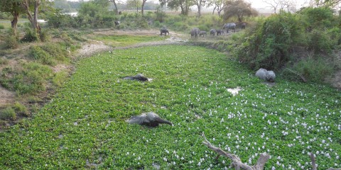
Elephants. Many elephants. Looks like mamas, grandmas, toddlers, teenagers. Lumbering along. Mix and match. Where are they all going? Oh wait! I see. Between the trees. They are climbing up and over a small hump in the brown earth and then making a splash.
But I am too far away. I want to be closer. The guide drives up onto a slatted wooden bridge. And there below on both sides in a lovely pond just filled with pink water hyacinths in riotous bloom, the elephants are having a pool party.
Walking, swimming, eating, playing.
Part in, part out of the water, they look half black and half white.
Some have vegetation sticking to their heads, their massive backs.
They yank big clumps of vines from the water and swing them to and fro with their trunks, freeing the greens of mud and dirt. Perfect for feasting. Must be joyous for them. I know it’s joyous to watch.
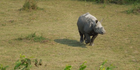
I have never really thought about rhinos skipping. You know what I mean, skipping like children do. But I saw it with my own eyes.
The mother rhino crossed the road right behind her baby. You could tell she was a baby. She just had that cute, mischievous look in her eyes.
And she was happy. Happy to be free, to roam in wide open spaces, to have plenty to eat and to play. And then it started. She was skipping, running around like crazy. Back and forth, running circles around her mother. All four feet off the ground at once.
Mom had that look on her face, tolerant but put upon, as if to say “those kids!” This went on for quite some time, baby going in bigger and bigger circles, until finally, exhausted, she sidled up to her mother and resumed walking, blase, just as though nothing had ever happened.
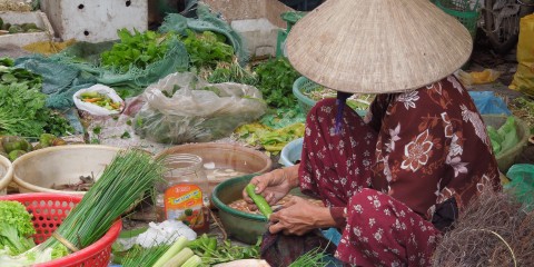
I am in Delhi, the capital. It is Election Day. Election Day is different in each of the thirty-one Indian States although they all take place within one month. Everyone over eighteen must register to vote and is given a voting ID card. There are many polling stations, one on nearly every street staffed by poll workers making it easy to cast a vote. And it is a holiday so the normally gridlocked streets are quieter, more manageable. Nevertheless, the city is alive with cars and buses honking, the clatter of rickshaws operated by foot or motor,
ubiquitous yellow and green three-wheeled taxis,
bicyclists, carts pulled by humans or horses,
pedestrians carrying all manner of goods on their shoulders, on their heads, all vying for the same limited space.
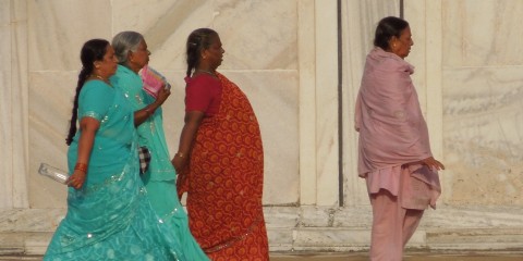
Women in beautiful saris, so much color, turquoise, purple, coral, red, bright yellow, bangles, rings.
The smell of spices fills the air- cardamom, cinnamon, coriander, fennel- and mixes with the smell of sweat.
I fly to Jodhpur, the blue city, so called because the rich painted their houses blue. This sight is wonderful to behold from the Mehrangarh Fort high above the city.
The Fort has been run by the Maharaja of Jodhpur since the 1500’s and is filled with the trappings of Indian royalty.
During the long drive to the rural city of Siana, there are cows in the road standing stock still,
people selling,
standing, smoking, cow dung, garbage, dust, potholes, speed bumps, slow-moving buses and trucks over-loaded, precariously overtaking each other, sometimes three abreast.
On Pradeep’s farm where I stay, the evening is breezy, early morning cool. I am awakened by the cacophony of peacocks screaming, horses whinnying, monkeys in the trees calling, dogs barking, farm equipment working, birds singing. Later, it gets hot, very hot. Feet burn, throat is parched. I ride a camel for two hours through the desert to the remote sheep herder town of Nabi and visit with the villagers, the school children.
Each of these experiences reminds me of the joy of travel, the thrill of being in worlds so very different from my own.
Namaste
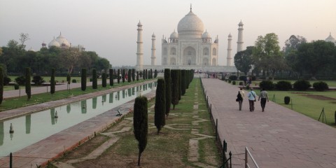
In Agra, I visit the Taj Mahal (Crown Palace) at sunrise and again at sunset. It is magnificent.
Designed by three architects and built for Emperor Shah Jahan over twenty-two years ending in the 1660’s, it was a mausoleum in honor of his Queen, Mumtaz Mahal. It was constructed of locally quarried white marble found nowhere else in the world, decorated with semi-precious stones (long-since plundered) and her gravesite itself was covered in a blanket of emeralds (also long gone). The building is entirely symmetric in every aspect with one exception. The Queen’s grave is in the exact center of the building. The Emperor’s was placed to the left of it. He had also had a huge mosque built on one side of the Palace and in order to keep things in symmetry, he had an exact copy built on the other side! Obviously, money was no object.
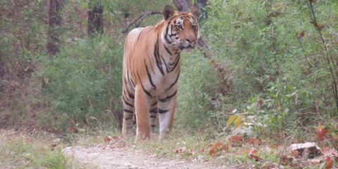
Now I am in Kanha National Park, an hours flight west of Kolkata. The purpose here is to see tigers. The size of the park is 1945 square kilometers of which twenty percent is accessible to visitors. There are ninety-six tigers living here. Not great odds of seeing one. After four visits, I had seen claw marks in a tree where a tiger marked it’s territory. I had seen fresh paw prints in the sand.
I had seen no tiger. However, there was high drama on the fifth visit. The jeep in which I was riding approached two other jeeps that were already parked on the road in front of a forested area. The guides signaled my guide to cut the engine and be silent. We waited expectantly as more jeeps arrived and then sat quietly. We waited and waited. The tension mounted. There was a tiger in there just a few meters from us. Would she come out? Would she cross the road? I struggled to see her. I could just make out some stripes, a face camouflaged by the foliage. And then, oh no! she arose and sauntered deeper into the woods away from the waiting throng. Well, I almost saw a tiger. Maybe next time!
So, yes, I saw a tiger. Two in fact. It was 6:30 am, just after arriving in the park. I was with three guides in the jeep: Devend, Guddu and Akbar. Just the four of us. They were looking at tracks in the sand. They saw some in both directions on the road. Which way to go? They chose. We saw that another jeep had already parked. The guide in that jeep signaled “tiger.” Guddu cut the engine. There were only the two jeeps there, them and us.
Silence.
A few minutes passed and out of the woods from our right came a handsome, powerful-looking male tiger.
He walked away from us on the road, in no hurry.
He then entered the woods to our left and lay down.
He stayed there but a short while and then got up and entered the road again heading straight for us, so close Guddu had to back the jeep up. We made eye contact, the tiger and I. He looked serious, regal, intimidating.
All the while we snapped pictures, the guides and I. It was thrilling, unforgettable. A while later, the tiger’s two and a half-year-old nearly-grown cub made a brief appearance.
But it was his dad I will never forget.
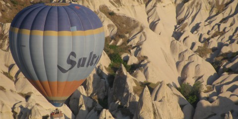
Fairy chimneys. That’s what they’re called. Fascinating volcanic rock formations fashioned through centuries of wind, rain and river flow.
Cream colored, pink, yellow even. Many are caves that were lived in by hermits long ago, later by Christians who carved monasteries into the caves, painted beautiful frescoes on the walls and ceilings, often still perfectly intact today. Other caves were bedrooms, kitchens, wineries and granaries. Little covered ledges were carved into the sides of the rocks for pigeons to roost, the dung collected by farmers to fertilize their crops planted around and between the rock formations. Long, thin slits were cut into the stone for bees to nest, producing honey for the local people.
Elsewhere, vast underground cities connected by extensive tunnels, led to living quarters, stables, ventilation systems and wells, eight stories deep.
These housed as many as 60,000 Christians who sought refuge from invading Arabs for up to three months at a time.
This is Cappadocia, a magical place in central Turkey, an hour’s flight from Istanbul. Here, you can hike in the valleys, climbing onto the rocks and into the caves, imagining what life was like one thousand years ago.
You can go up in a hot-air balloon at sunrise and get yet another perspective of this whimsical-looking place, where you are aloft with dozens of other brightly colored balloons, rising up and then descending into the valleys on the air currents, so quiet and serene.
Sua s’dei (hello) from Siem Reap Cambodia
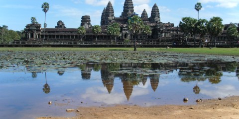
Now you are in Siem Reap which means “Siamese defeated” and refers to the Khmer victory over the Siamese in the 17th century. In Siem Reap, you visit the many antiquities, most notably the Angkor Wat complex.
You explore these remarkable places on foot and by bicycle over the course of 3 very full days. You do so with a guide who has a compelling history. In 1975 at the age of 7, he and his educated parents were moved by the Khmer Rouge from the city where they lived to the countryside. Rith was separated from his parents who were then killed.
He was made to collect dung and if he was unable to, he was not fed. In 1979 when the Khmer Rouge were finally overthrown by the Vietnamese, more than 3,500,000 people had lost their lives in the killing fields. Rith was educated by the government because he was an orphan. He never again saw any member of his family.
In the temples, the carvings on the walls depict religious stories and life in the 12th century. At the height of the Angkor period between the years 1113 and 1150, there were more than a million people living in Angkor Wat and 40,000 working elephants. It is the largest religious structure in the world, considered by some to be the eighth wonder.
You marvel at the size, the architecture, the detail, how much of it remains. You walk on the same stones as the people did nearly 1000 years ago.
Aw kohn (thank you).
Sabaydee (hello) from Ventiane Laos,
The fog lies heavy on the Mekong River. The Mekong conjures up many thoughts of another era, war and destruction. It is remarkable to be here. As the fog lifts, you cross by boat from Thailand to Lao PDR. You begin your journey in Laos and it is a revelation, much different than you expected. It is lush and green and very mountainous.
It is dotted with many villages, homes of thatch and bamboo.
You hike in Luang Namtha province through thick jungle and steep paths used for centuries by the Lanten and Khmu people. They have their own languages and are animists. You cycle to Wat (temples) and stupas (shrines) in the countryside.
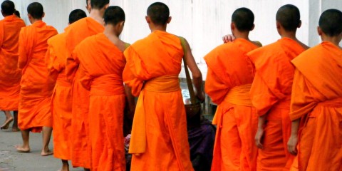
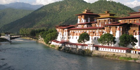
Then you spend three memorable days in Luang Prabang, once the capital of Laos when it was a French colony and is now a UNESCO World Heritage site. It is situated at the confluence of the Mekong and Nam Khan rivers, a beautiful place, quiet and elegant. You rise at 5:30 am to see the monks in their orange robes leaving early morning prayers and being offered alms by the citizens of the city.
You cycle to a far-off waterfall and swim in the blue water, a welcome cooling-off after a very hot and challenging ride.
You take a long boat on the Nam Khan to a trailhead and hike to the remote villages of the Hmong people. You watch them harvest rice in the fields and weave bamboo. You see the children play and giggle, so different, yet the same as children everywhere.
You continue to marvel at the variety of people and cultures you are seeing every day.
Khawp jai (thank you).
Sawasdee (hello) from Chiang Mai Thailand
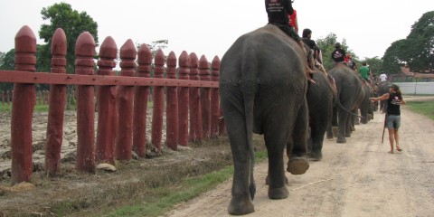
Now imagine staying on a working elephant farm and you are temporarily part of the staff. The national symbol of Thailand is the Asian elephant, traditionally used in war and as a beast of burden. One hundred years ago, there were 300,000 elephants in Thailand. Today, there are only 3,500 of which 1,500 live in the wild. A Thai man decides to keep alive the tradition of elephants as working animals and begins a rescue and breeding program. There are approximately 90 elephants on the farm, a huge tract of land. You stay for 3 days. You are partnered with an 80 year old retired female elephant named Dokma. You help prepare elephant food, feed the animals (they eat A LOT), clean up after them (there’s A LOT to clean up), give them exercise twice a day by riding them (you sit on the neck, the mahout directly behind you) through the streets of Ayuthaya
and into the river for a cool bath (needless to say, the elephant, the mahout and you all get the bath).
You play with the 17-day-old baby named Opal; she is absolutely precious.
You watch Peter the elephant paint you a picture.
You watch the mahouts expertly direct the elephants to load and unload tons of grasses, bananas and pineapples. It is an unforgettable experience.
You take an overnight train to Chiang Mai and begin a trek to the hill tribe country north of Chiang Mai. It is mountainous and cool. The trekking is challenging. You are carrying all that you need for 3 days on your back. You stay in different villages each night. The people are from the Karen tribe, originally from Tibet.
They establish villages in the mountains of northernThailand. Just 15 years ago, they are recognized by the Thai government and become citizens. Their lives have changed little. They subsist by growing and harvesting rice. They weave and make jewelry. They open their simple bamboo homes to guests. You bathe in the river. You visit the local school and sing songs with the young children. They know the same songs you sang as a child. It is memorable.
Each day, you feel so lucky to be traveling, learning and living.
Kob Koon Ka (Thank you)
Kuzoozanpo la (hello) from Paro Bhutan!
Imagine driving for hundreds of kilometers on a road so winding your speed averages 30 kmph. The drop-offs are heart-stopping. There are no guardrails. It is the only east-west highway in the country. It hugs every mountain curve. There are no flat or straight places. The road is so narrow, opposing traffic is often in your lane. You reach the village of Shingkhar, the easternmost village in central Bhutan, altitude 11,500 feet. Nothing has changed here in hundreds of years except that recently, cell phones have brought communication from the outside world. There is no electricity. Heating is by wood burning stove. Warmth in your bed is provided by hot water bottles.
Early in the morning, you awaken to have a hearty breakfast of porridge, eggs, toast and tea. You walk to the local elementary school and watch the children in their traditional dress of ghos and kiras sing at assembly.
Your daughter reads to a class from books she has brought from home to give to the children.
From there, you set off on a trek through the village and up into the inner Himalaya mountains. The trek is steep. The horses carrying the tents, food and supplies have a hard time with their footing. You arrive at the pass, the tents are pitched, the fog rolls in. It is very cold. There is a bonfire and dinner, stars in the heavens like you’ve never seen before. You are at 12,700 feet. You crawl into your sleeping bag, difficult to find any warmth.
You are awakened at 3AM. You have breakfast and set off at 4AM with your flashlight to be at the summit at sunrise. You trek through a frozen rhododendron forest. It is 0 degrees C; 16 degrees F. You reach what feels like the top of the world. You can see all of Bhutan from the 14,000 foot summit. Layer upon layer of mountains: the lesser, inner and greater Himalayas, rising to over 28,000 feet. The sky is cloudless. It brings tears to your eyes. You are so grateful to witness this; you feel lucky to be here.
The trek down is steep and beautiful. After 7 hours, you return to the earth.
Another day, you leave from the village of Phobjikha on an even windier unpaved road. Your speed is steady at 5 kmph. You arrive at the trailhead and trek 5 hours to the summer home of a former government minister. Elegant and fit at the age of 69, Mr. Lahtu invites you into his home as a welcome guest.
No western traveler has ever been to his home or his village of Khotokoa. He gives you delicious food and homemade drink. You meet his grandchildren who are beautiful and full of joy.
You go back to your tent satiated and amazed, once again, at your good fortune to be experiencing Bhutan from the inside.
There is so much more to tell. But I have given you the essence. It is a place like no other.
Kaadinchhey la (thankyou).
My daughter and I went on a two-week trip to New Zealand in her senior year of high school. She took an extra week of spring-break. Except for a few days in Wellington on the North Island, we spent most of our time on the South Island. It was the time of “The Lord of the Rings” craze and Juliet was a devotee. She even spoke Elvish. So our itinerary included visits to some of the filming locations. From our vehicle, we even saw Peter Jackson’s Oscar sitting on a window sill in his house!
We also hiked the three-day Routeburn Track, an exquisite 26-mile hut-to-hut trek that in addition to its beauty, was known for its colossal amount of rainfall, reputedly three to nine feet a year. How lucky we were, then, when we had nary a drop.
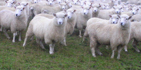
Another highlight was a two-night home stay on a sheep farm. There was a great deal of land, very hilly and overlooking a large bay. We stayed in the home of the farmer, his wife, and their children. The farm had four thousand sheep and three sheep-herding dogs to manage them.
We were given Wellies to wear on our feet. The ground was challenging to navigate due to the undulating landscape and the extraordinary amounts of sticky black mud everywhere. We followed the farmer and the dogs as they directed the sheep from place to place. When the farmer was finished with the outdoor sheep chores, he gave the dogs some signals and they expertly corralled the sheep into a huge barn where they were channeled down various chutes and branded with different paint colors depending upon the length of their wool. This, in turn, dictated which sheep were ready to be shorn.
This was definitely a new (and memorable) experience for us city-folk!
In Kathmandu, I don’t have a clue how to cross the street. There is never a break in the mass of cars, trucks, buses, bicycles, motorcycles and rickshaws. There aren’t any traffic signals and no stop signs. I figure the safest thing to do is to stand very close to someone who appears to live there and cross when he or she does.
There are many temples, Hindu and Buddhist. We see holy men and beggars. Funerals are taking place by the Bagmati River evidenced by the large burning pyres. The smell of smoke and incense fills the air.
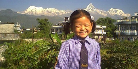
We are flying to Pokhara, the jumping-off point for a trek in the Annapurna Circuit. The weather is not good. In fact, it looks like pea soup. We are in a small plane, two single rows of passengers divided by a narrow aisle. I know we are surrounded by 26,000 foot mountains but I can’t see them. Neither can the pilot. I am sweating. I am terrified. We had been told that the flight from Kathmandu was to take half an hour. It was definitely taking longer than that. And then suddenly the plane slips out of the clouds. I see the city. But wait. It looks just like Kathmandu. Did they have the same architect? It is Kathmandu. Unable to land in Pokhara because of the weather, we had returned. We stay in the small domestic Kathmandu airport for hours waiting for the weather to clear. Finally, we are able to fly to Pokhara and then the next day, on to Jomsom. We tour the tiny town of Jomsom, remote and desolate. We visit a small hotel whose claim to fame is that Jimi Hendrix once stayed there and “his” room is decked out with various Hendrix memorabilia. We begin three days of trekking at just under 10,000 feet in elevation. Our wonderful guide, Mani Rai, assures us it never rains on the Jomsom side because it is in the rain shadow of the mighty Himalaya. It then rains for the next three days.
The only means of travel in this area is by foot or horse. As a result, we see people transporting unbelievable things on their backs: a washing machine; a cageful of chickens; a two by twelve board that is twenty feet long requiring the bearer of it to walk along the path sideways! We stay in a place that is so cold, the only source of heat is a small stove located underneath the table in the dining room. The bedrooms are unheated. We spend a great deal of time at this table trying to keep warm with the help of home-made peach schnapps that tastes terrible.
We then move to the Ghandruk side of the Annapurna Circuit and trek the 23,000 steps to the small hamlet of Ghandruk, at the foot of Machhapuchchhre, the “fishtail” mountain. Who counted the number of steps is unknown (I certainly did not but can attest that there were many). We traverse hanging bridges that sway in the wind as we cross. The porters run across them carrying their heavy loads while wearing just flip flops. They seem other-worldly, never appearing to tire.
Our journey ends at the Rum Doodle Bar in the Thamel district of Kathmandu, a gathering place for trekkers, where we toast our good fortune in having experienced the beauty and culture of Nepal.
I am a cultural Jew. What that means to me is that I don’t adhere to the religious part but relate to other less well-defined but recognizable aspects of being Jewish. It’s really hard to explain.
In any event, I went to Israel for the first time in 1978. I came by boat from Piraeus in Greece. As the boat approached Haifa harbor, I saw many steel grey ships of varying sizes. While this did not seem particularly remarkable, there was one difference here. The writing emblazoned on the bows of these ships was in Hebrew.
I started to cry. For the first time in my life, it felt like I was part of the majority culture.


Tasmania (February 2019)

Raja Ampat, Indonesia

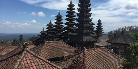
Bali, Indonesia

Guilin, Yangshuo, China


Xi'an China

The Great Wall, Beijing, China

Ho Chi Minh City (Saigon), Vietnam

Hanoi, Vietnam

Kazaringa National Park, India

Kazaringa National Park, India

Delhi, India

Agra, India

Kanha National Park, India

Cappadocia, Turkey

Siem Reap, Cambodia

Luang Prabang, Laos

Ayuthaya, Thailand

Bhutan

New Zealand, South Island

Nepal
Haifa, Israel